|
|
Geography
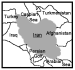
Iran is a country measuring sq. km 1, 648,000 (water sq. km 1200), slightly larger than Alaska. Iran is an Islamic republic government; placed in Middle East and surrounded by:
1- Turkey (499 km) and Iraq (1458 km) from West;
2- Turkmenistan ( 992 km), Azerbaijan (936 km) and Armenia ( 35 km) from North ( +740 km. To Caspian Sea);
3- Arabian Sea and Persian Gulf ( 1770 km ) from South;
4-Pakistan (909 km) and Afghanistan (936 km) from East;
In 32.00 N and 53.00 E.
It's total land borders are km 5170 and it's total marine border in the North and South is Km.2150.
Iran stays at the heart point of the Middle East and is counted as one of the most important oil producer's country. Iranian natural scenery is marvelous and remember able; its various fountainheads, beautiful gardens, numerous jungles and spectacular sceneries are unforgettable. One of the particulars of this big country worth mentioning to tourists are the high mountains all through the land prairies and deserts, rivers and lakes so that one may see at any time a magic of the Four Seasons around the country.
The height of Iranian plateau is a reason for elevation of most of provinces to stand higher than 1000m. with high peaks; the most famous peaks are:
Damavand at North east of Tehran, 5671m. height
Sabalan at west of Ardebil, 4880m. height
Sahand at south Tabriz, 4707m.height
Takht Solomon in central Mazandaran, 4820m.height
Zardkuh, Bakhtiari 4550m.high
Dena at north of Yassuj 4309m.high
Taftan at south Zahedan 3941m.high
Deviation and miscellaneous lime layers, has created many caves in Iranian provinces specially in Azerbaijan, Kurdistan and Hamadan.
Southern coast of Caspian sea, a very vast region with forest-covered foot in with altitude of 28m from the sea level with the most beautiful sceneries are very spectacular.
Maritime Claims
Contiguous zone: 24 nm
Continental shelf: natural prolongation
Exclusive economic zone: Bilateral agreements, or median Lines in Persian Gulf.
Territorial sea: 12nm
Elevation extremes
Lowest point: Caspian sea 28 m.
Highest point: Damavand peak 5671 m.
Natural resources
Petroleum, natural gas, coal, chromium, copper, iron ore, lead, manganese, zinc, sulfur.
Land use
Arable land: 10%
Permanent corps: 1%
Permanent pastures: 27%
Forests and woodland: 7%
Other: 55% (1993)
Irrigated land: 94000 sq. km (1995)
Natural Hazards
Periodic droughts, floods, dust storms, sandstorms, earthquakes along Western border and in North-East.
Environment-current issues
air pollution, especially in urban areas, from vehicle emissions, refinery operations, and industrial effluents; deforestation; overgrazing; desertification; oil pollution in Persian Gulf; inadequate supplies of potable water.
Environment-international agreements
Party to: Biodiversity, Climate Change, Desertification, Endangered Species, Hazardous Wastes, Marine Dumping, Nuclear Best Ban, Ozone Layer Protection, Wetlands signed, but not ratified: Environmental Modification, Law of the Sea, Marine Life Conservation.
Weather
Iranian plateau has a rather dry climate, while the country stands in the dry climate belt. High mountains such as Zagros and Alborz prevents crossing humidity into central part and the average heat annual heat increases from northwest to South and South-East (from 4 degree in Azerbaijan to 30 degree C. in South and Southeast; annual rain differs from 2000mm. in Guilan to less than100mm. in central regions; the average rainfall is about 275mm. The best climate is in northern provinces specially Nour valley, Kojur, Klardasht, Katalom, Azerbaijan, Khorasan, and central regions of Zagross chain.
|
|